 Catálogo de Datos Abiertos Geoespaciales
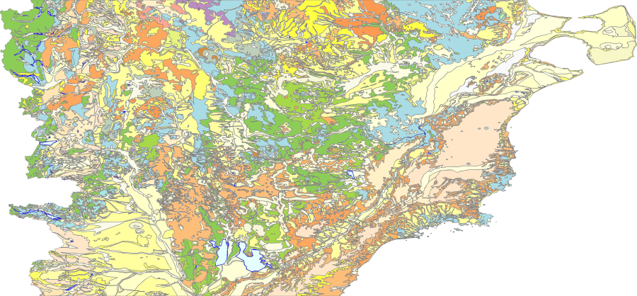
Prov. Chubut Unidades Geologicas 750K
Simple
- Date (Publication)
- 2021-03-05T09:33:00
- Status
- Completed
+54 11 5670-0100
https://sigam.segemar.gov.ar
- Maintenance and update frequency
- As needed
- Theme
-
- features
- e750K.ProvChubutGeol
- Mapa Geológico Provincial de Chubut
- Chubut
- Geología
- Access constraints
- Other restrictions
- Other constraints
-
La información y los datos producidos por el SEGEMAR, y publicados en SIGAM, están disponibles bajo la Licencia Creative Commons Atribución 4.0 Internacional (CC BY 4.0). https://creativecommons.org/licenses/by/4.0/deed.es
Se permite su uso, copia, modificación y redistribución (incluidos productos derivados), siempre que se reconozca debidamente la autoría institucional y se cite la fuente original.
- Spatial representation type
- Vector
- Denominator
- 750000
- Metadata language
- Spanish; Castilian
- Character set
- UTF8
- Topic category
-
- Geoscientific information
))
- Supplemental Information
- Programa Nacional de Cartas Geológicas y Temáticas de la República Argentina. Banco Nacional de Información Geológica.
- Reference system identifier
- CRS:84
- Reference system identifier
- EPSG:4326
- OnLine resource
-
sigam:e750K.ProvChubutGeol
(
OGC:WMS
)
Prov. Chubut Unidades Geologicas 750K
- OnLine resource
-
sigam:e750K.ProvChubutGeol
(
WWW:LINK-1.0-http--link
)
Prov. Chubut Unidades Geologicas 750K
(WFS). El conjunto de datos está publicado en el servicio de descarga (WFS) disponible en
- OnLine resource
-
sigam:e750K.ProvChubutGeol
(
WWW:DOWNLOAD-1.0-http--download
)
Prov. Chubut Unidades Geologicas 750K
(SHAPE-ZIP)
- OnLine resource
-
sigam:e750K.ProvChubutGeol
(
WWW:DOWNLOAD-1.0-http--download
)
Prov. Chubut Unidades Geologicas 750K
(GEOJSON)
- OnLine resource
-
sigam:e750K.ProvChubutGeol
(
WWW:DOWNLOAD-1.0-http--download
)
Prov. Chubut Unidades Geologicas 750K
(CSV)
- OnLine resource
-
sigam:e750K.ProvChubutGeol
(
WWW:DOWNLOAD-1.0-http--download
)
Prov. Chubut Unidades Geologicas 750K
(KML)
- Statement
- Fuente: Ardolino, Alberto A.; Anselmi, Gabriela; Giacosa, Raúl Eduardo; Chavez, Silvia Beatríz; Álvarez, María Dolores; Benítez, Javier; Pucheta, Alicia, 2022. Mapa Geológico de la Provincia del Chubut, República Argentina. Escala 1:750.000 Buenos Aires, Servicio Geológico Minero Argentino. Instituto de Geología y Recursos Minerales. https://repositorio.segemar.gov.ar/handle/308849217/4230
- File identifier
- 36f6770fcc65bf15bf581b1746c3d900e2d93ed5 XML
- Metadata language
- Spanish; Castilian
- Character set
- UTF8
- Date stamp
- 2025-10-08T11:42:28
- Metadata standard name
- ISO 19115:2003/19139
- Metadata standard version
- 1.0
Metadata author
+54 11 5670-0100
https://sigam.segemar.gov.ar
Overviews
Spatial extent
Provided by